Welcome to Spatial Markets NC
-

Service Area
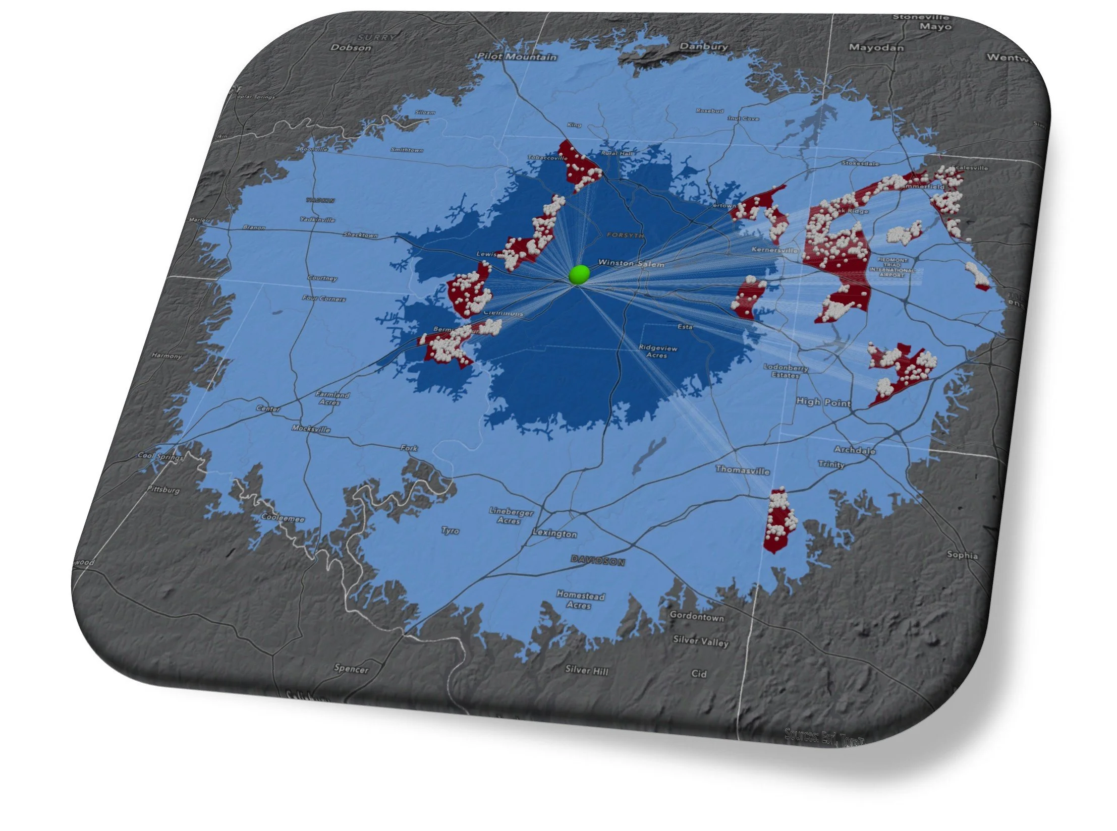
This drive time map layer conveys movement by vehicle, bicycle or foot using the precise transportation network and traffic density that influences our daily lives. Choose a time of day, week month or year to see how the service area expands and contracts under a variety of traffic models.
Most importantly, the Service Area map layer identifies spatial extent of your market reach.
-
Advanced Economics
Within a Service Area, we identify the highest impact neighborhoods with a proven interest in your campaign message, service or product.
Our Advanced Economics mapping platform provides direct spatial indicators on all matters of human, economic and environmental geography.
-

Precision Locator
Our Spatial Markets NC Precise Locator tool supports extensive and strategic filtering at the individual level. This ensures your outreach efforts are directed to the individuals who meet the precise profile matching your needs.
Whether it’s at the statewide or neighborhood level, the Precise Locator tool cuts through the noise to identify strategic contacts for nearly any mission.

At Spatial Markets NC, sound data science principles, human, economic, and environmental geography guide our data analysis & product development. We work with a variety of subject matter experts to craft precise targeting algorithms within our custom three-tiered mapping application to achieve strategic market connections and analysis.
-
Every business has one, it could range from a neighborhood block, to the state and beyond. If you need to know where your customer base lives in proximity to your business, this is the preferred method.
We find for most brick & mortor, or service related industry that a drive time, or drive distance based map is the best spatial filter for step 1 of our process.
Clients can chose from a variety of service areas unrelated to roads, from county to statewide, or beyond. Our Advanced Economic Mapping, and Customer filter ensures your message connects with the intended audience.
Additionally, we offer drive time mapping based on year, month, day, hour, which can make a large difference. (see example). Typically, a 5 P.M. drive time is our recommendation, but we engage with you to set the best time or distance. We want to take as much care at this step to ensure proper identification of your reach.
These are a vast improvement over the simple, “as the crow flies” boundaries used in many big data company filters.
-
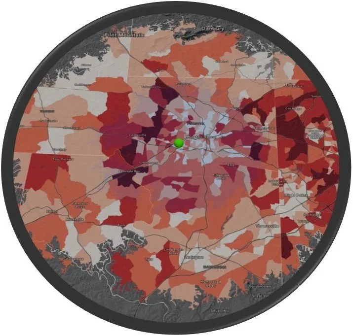
Our team has specialty in identifying high impact geographies based on joins, and spatial overlay analysis. We work with a variety of environmental, health, economic and cultural mapping data to meet client needs.
Our utilization of Advanced Economic Mapping allows us to identify with great precision, the exact neighborhoods where the highest concentration of consumers in your specific market reside. Geocoded consumer spending, economic behavior, cultural traits, and more,
We can determine the availability of data strategic to your business case at no charge.
This mapping portal can facilitate strategic outreach like no other, when coupled with Service Area mapping you can really see the benefits.
With the “Where” solved, we can dive into the “Who” in the Customer Identification step where we will isolate the precise population based on the customer profile you want and know to be profitable.
see other examples of our AEM data -
While phases 1 and 2 of our filtering process captures strategic and high impact geographies such as neighborhoods, we know that not every resident is interested in your service of product.
We specialize in isolating the precise individual consumer profile that matches your business needs. We collaborate with you in an easy and efficient process to list out the personal characteristics, demographics, income parameters and more.
We can target households based on demographics, age, rent/own, # of occupants, structure age, last sale date, marital status and much more. Most often we utilize Age and # of Occupants, however we specialize in mapping a very precise recipient, so don’t hesitate to share your most specific request!
3-Tier Filtering with Spatial Markets NC
Make your connections with a science based marketing strategy.
Precision Locator: Commercial
Business locator mailing lists filtered by keywords, industry type, business name, employee count or annual sales volume. Within our Precision Locator program we offer identification of all NEW business to North Carolina. Check out of growing 2025 NEW BIZ registry in our interactive GIS mapping application HERE.
Precision Locator: Residential
We offer a level of specificity in our filters that will make you reconsider the value of targeted mailings, or phone based leads. Focus your next “targeted” mailing or outreach effort on the most filtered profiles available at Spatial Markets NC.
Our strategic GIS platform offers a results oriented, data driven methodology to facilitate very effective connections.
We welcome your outreach, our team specializes in identifying the high impact neighborhoods that align with your message, and pinpointing the precise individuals within for targeted outreach by mail, phone or very select D2D use.
Our comprehensive targeting operations begin with you in the lead. While we offer expertise and deliver direct support in the identification process, we believe strongly that you know your market and target audience best. We offer an efficient, collaborative experience to ensure each phase of filtering is effective, transparent and involves you, the subject matter expert.