We examine the NC GOP lead redistricting - October 2025

our desktop dashboard offers a comprehensive review of populations for a variety of campaigns.

mapping the Unaffiliated - North Carolina
The Voter Locator Map - Unaffiliated turns cumbersome big-data into strategic information with just a few clicks.
instructions:
- Video
access restrictions apply, please contact.

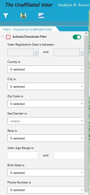
Screenshot of our Voter Locator Application - Filter page. Simple, Advanced spatial, temporal and demographic filtering of >2.8 million registered unaffiliated voters (blue dots) for the 2024 election.
analysis and access

Find your new voter base with strategy. Apply spatial, temporal and demographic filters to our 2.8 million record map layer with a very simple interface.
Integrate polling data into our filtering panel to locate hot spots from our 2.8 million record map dataset.
It’s often stated that a particular demographic is polling well with a certain campaign, our Voter Locator Map can precisely map that audience. In just a few clicks you’ll have the strategic information to engage in outreach and advertising.

Unaffiliated
The single largest bloc of voters in NC.
Inset image shows parties with ballot access in 2024.
- voter locator map - Unaffiliated
Political parties running elections in North Carolina are acutely aware of how our ~2,8 million registered unaffiliated voters are potential supporters of thier campaign.
With our easy to use, yet advanced mapping platform these 2.8 million records become strategic information for outreach, organizing, voter recruitment and advertising in just a few clicks.
Our Voter Locator Map provides direct access to these >2.8 million registered unaffiliated voter map points with the associated residential address map point, gender/sex, age, race, date or registration, birth state data, phone numbers and more.
Map based analysis is key for finding the unaffiliated voters that align with your message with. The Voter Locator Application provides the platform needed to map the exact audience you need for high impact advertising, event planning, organizing, voter recruitment and more.
Reach out for a demo
Access Requirements exist for the Voter Locator Application.
access to…..
Spatial filters based on zip code, county, or manual selection, if needed, will allow you to limit analysis of the 2.8 million records available within this application and assess your area of interest more directly.
Registration date filtering visualize temporal patterns and waves of party growth with this important metric.
Demographic filtering of the 2.8 million records can reveal precisely where to focus advertising and outreach when polling data suggests a specific segment of the voter base supports a campaign or idea.

- Add and analyze socioeconomic, spending and consumer behavior, and US Census map data to strategically identify the registered unaffiliated you need.
example showing registered unaffiliated voters intersected with a vehicle availability map layer from US Census.

- Interactive graph tool that filters based on manual selection, map extent, or all*
example showing age range of registered unaffiliated voters at the neighborhood level.
- Download or Access spreadsheet of filtered voter lists in one click.
- Contains GPS service to support volunteer field organizers with the best available, easiest to use mapping tools.
we have Voter Locator Maps and geocoded voter registration data for all parties listed in panel C.
Schedule a Demo of our Unaffiliated Voter Locator Application
Our NC based company provides all GIS modeling, coding and app development for this project and has expertise in mapping the human dimension using big data.
Density of party affiliation by Zip Code
This new Interactive mapping platform looks at the spatial distribution of all registered voters within North Carolina, by party affiliation at the zip code level.
or Sample the application here by moving the sliders for any of the parties that interest you, or start by picking a zip code or town.
Panel A – See party hot spots and low registration by zip code for any party, adjust sliders to right or left accordingly.
Panel B – Select zip codes you are researching to assess party competitiveness and composition of registered voters. Download list!
Panel C – Updates with any single, or multiple selection from Panels A, B and D.
Panel D – Select town names to filter dashboard to visualize the party composition within.
layers and filters - the where and who of advertising
Spending habits and consumer behavior mapped to the neighborhood level brings strategy to campaign outreach
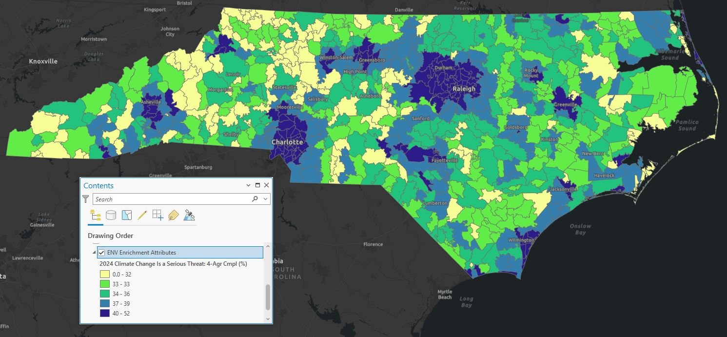
Environmental
Voters?
Percentage of residents (by Zip Code) who Strongly Agree that Climate Change is a Serious Threat.

Enrich
Enrich voter registration data with specific consumer behaviors mapped to the zip code and census tract/block level of detail.
Add strategy to your campaign outreach.
1. Choose an Enrichment Map layer
2. Set an effective threshold.
3. Highlight Unaffiliated Voters!
for a more comprehensive review of enrichment map layers, contact me. The list here is a sub sample for demonstration purposes.
Overlay analysis with the Unaffiliated Voter Registration will identify zip codes and neighborhoods where voters are, at a minimum, exposed to or familiar with a consumer behavior, and of course, at best conditioned to support or vote for campaigns aligned with a behavior that aligns with a campaign.


Iterative overlay operations with other enrichmnent layers can add validity assertions made about audience.
This example looks at % of residents (by zip code) who contributed to an environmental organization within the last year.


after the 2nd overlay the Unaffiliated voter count reaches 850,000 for an environmental outreach campaign by mail or phone, or other organizing.